No Photo
Property Record
Highway 59, Carnesville, GA 30521
NEARBY LISTINGS FOR SALE OR LEASE
Property Detail
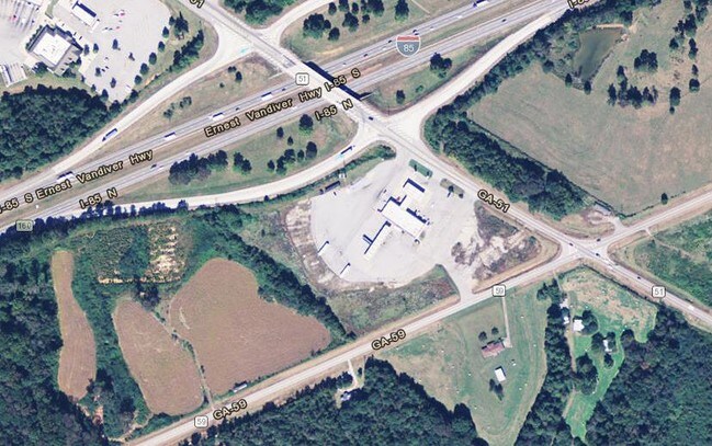
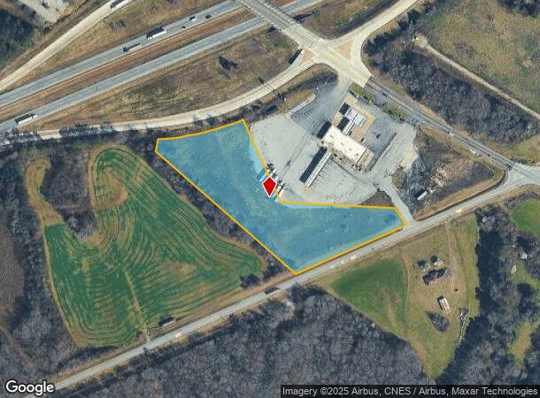
Highway 59
021-012-A
Ycs Investments Inc
Commercialacreage
3.80 AC I-85 & HWY 59 BEHIND SHELL STA
X
Franklin
13195C0025C
Georgia
2025
3.80 AC
2025
Georgia Northeast
890201
Other Market Areas
DEMOGRAPHICS near Highway 59
1 Mile
3 Mile
5 Mile
2024 Total Population
54
1,201
3,922
2029 Population
58
1,291
4,243
Pop Growth 2024-2029
+ 7.41%
+ 7.49%
+ 8.18%
Average Age
42
41
41
2024 Total Households
20
456
1,473
HH Growth 2024-2029
+ 10.00%
+ 7.24%
+ 7.88%
Median Household Inc
$52,500
$57,287
$55,911
Avg Household Size
2.40
2.60
2.60
2024 Avg HH Vehicles
2.00
2.00
2.00
Median Home Value
$250,000
$264,374
$222,587
Median Year Built
1990
1990
1990
Nearby Places
Map Layers
Map Styles
 Street
 Aerial
- Restaurants
- Banks
- Shops
- Fitness
- Groceries
SALE & LEASE HISTORY
LISTING DATE
SALE/LEASE

Sep 24, 2016
For Sale
Nearby Properties
Address
Land Use
TOTAL SIZE
Lot Size
Zoning
Address
Land Use
TOTAL SIZE
Lot Size
Zoning
1,500 SF
31.67 AC
UNZONED RU
Address
Land Use
TOTAL SIZE
Lot Size
Zoning
17,840 SF
36.64 AC
COMMERCIAL
Address
Land Use
TOTAL SIZE
Lot Size
Zoning
13,497 SF
32.18 AC
COMMERCIAL
Address
Land Use
TOTAL SIZE
Lot Size
Zoning
8,526 SF
20 AC
UNZONED RU
Address
Land Use
TOTAL SIZE
Lot Size
Zoning
1,750 SF
262.05 AC
UNZONED RU
Address
Land Use
TOTAL SIZE
Lot Size
Zoning
1,968 SF
207.35 AC
UNZONED RU
Address
Land Use
TOTAL SIZE
Lot Size
Zoning
62.31 AC
UNZONED RU
Address
Land Use
TOTAL SIZE
Lot Size
Zoning
209.08 AC
UNZONED RU
Address
Land Use
TOTAL SIZE
Lot Size
Zoning
32.82 AC
UNZONED RU
Address
Land Use
TOTAL SIZE
Lot Size
Zoning
156.90 AC
UNZONED RU
Address
Land Use
TOTAL SIZE
Lot Size
Zoning
178.05 AC
UNZONED RU
Address
Land Use
TOTAL SIZE
Lot Size
Zoning
181.33 AC
UNZONED RU
Address
Land Use
TOTAL SIZE
Lot Size
Zoning
672 SF
5.48 AC
UNZONED RU
Address
Land Use
TOTAL SIZE
Lot Size
Zoning
166.60 AC
UNZONED RU
Address
Land Use
TOTAL SIZE
Lot Size
Zoning
7,290 SF
2 AC
RESIDENTIA
Address
Land Use
TOTAL SIZE
Lot Size
Zoning
165.22 AC
UNZONED RU
Address
Land Use
TOTAL SIZE
Lot Size
Zoning
106.29 AC
UNZONED RU
Address
Land Use
TOTAL SIZE
Lot Size
Zoning
143.22 AC
UNZONED RU
Address
Land Use
TOTAL SIZE
Lot Size
Zoning
7,324 SF
15 AC
COMMERCIAL
Address
Land Use
TOTAL SIZE
Lot Size
Zoning
139.22 AC
UNZONED RU
Address
Land Use
TOTAL SIZE
Lot Size
Zoning
90 AC
UNZONED RU
Address
Land Use
TOTAL SIZE
Lot Size
Zoning
9,600 SF
3.67 AC
COMMERCIAL
Address
Land Use
TOTAL SIZE
Lot Size
Zoning
121 AC
UNZONED RU
Address
Land Use
TOTAL SIZE
Lot Size
Zoning
110.31 AC
UNZONED RU
Address
Land Use
TOTAL SIZE
Lot Size
Zoning
106.28 AC
UNZONED RU
Address
Land Use
TOTAL SIZE
Lot Size
Zoning
105.87 AC
UNZONED RU
Address
Land Use
TOTAL SIZE
Lot Size
Zoning
98.28 AC
UNZONED RU
Address
Land Use
TOTAL SIZE
Lot Size
Zoning
95.27 AC
UNZONED RU
Address
Land Use
TOTAL SIZE
Lot Size
Zoning
110.22 AC
UNZONED RU
Address
Land Use
TOTAL SIZE
Lot Size
Zoning
94.09 AC
UNZONED RU
The World's #1 Commercial Real Estate Marketplace
Connect with us
© 2025 CoStar Group
The information above has been obtained from sources believed reliable. While we do not doubt its accuracy we have not verified it and make no guarantee, warranty or representation about it. It is your responsibility to independently confirm its accuracy and completeness. Any projections, opinions, assumptions, or estimates used are for example only and do not represent the current or future performance of the property. The value of this transaction to you depends on tax and other factors which should be evaluated by your tax, financial, and legal advisors. You and your advisors should conduct a careful, independent investigation of the property to determine to your satisfaction the suitability of the property for your needs.